Mountain Biking / Running / Hiking / Skiing / Snowshoeing

La Crosse Trails

La Crosse Trails on Trailforks

(click and drag to move the map to see our trail systems)

Trailforks

Download the app for your phone or view their website

Trailforks WebsiteTrailforks (iPhone)Trailforks (Android)

Trail Maps

(click on the maps to expand them)

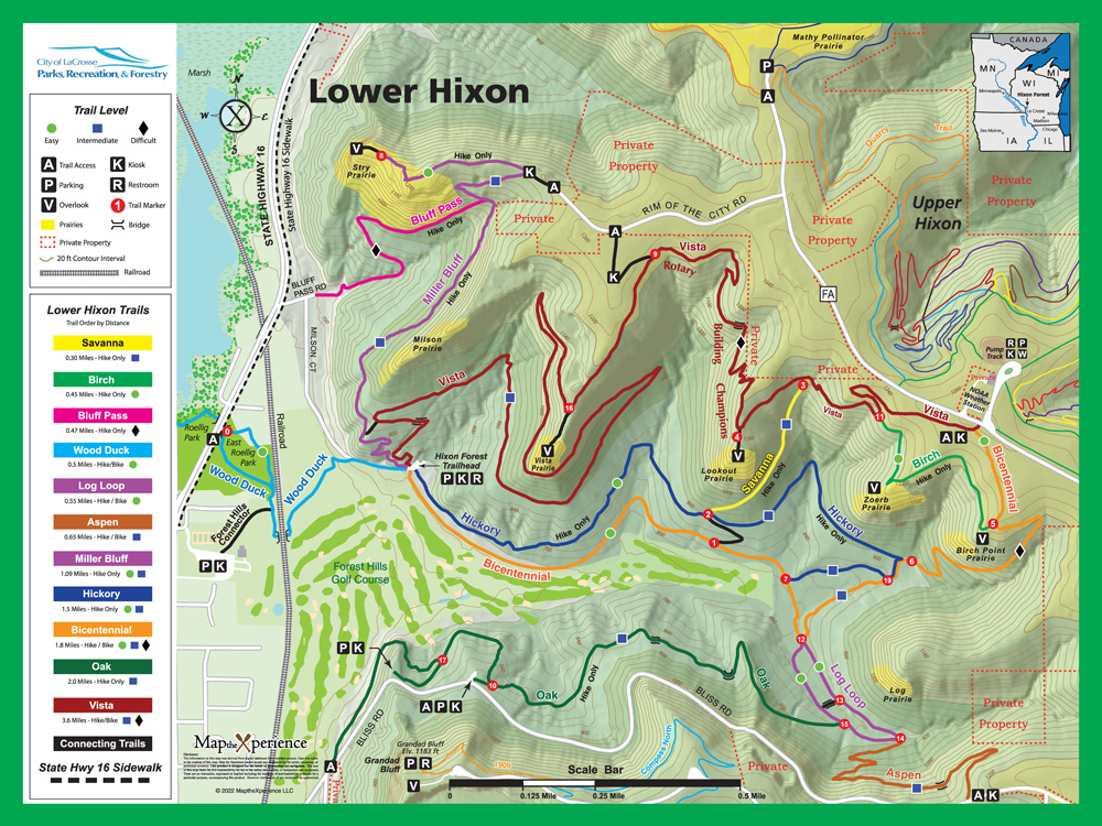
Lower Hixon Trails

Most trails are hiking and trail running only. Bicycles are permitted on Bicentennial, Vista, Log Loop, and Aspen.

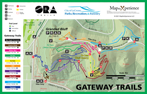
The Gateway Trails

The Gateway Trails are shared use trails for hiking, trail running, and biking with the exception of 1909 and Clara’s Climb which are hiking and trail running only. Users should take caution on War Eagle as bikers may be descending at a quick speed due to the nature of the trail.

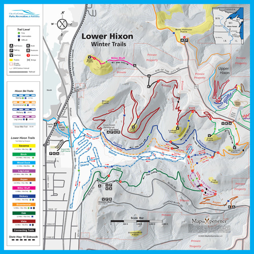
Lower Hixon Winter Trails

When the snow permits, there are groomed skate and classical tracks within Lower Hixon and the golf course as shown: Skemp, Bicentennial, Hickory, and Log Loop. Please be respectful of the ski trails and hike, run, and bike off to the side or avoid the area if you can.

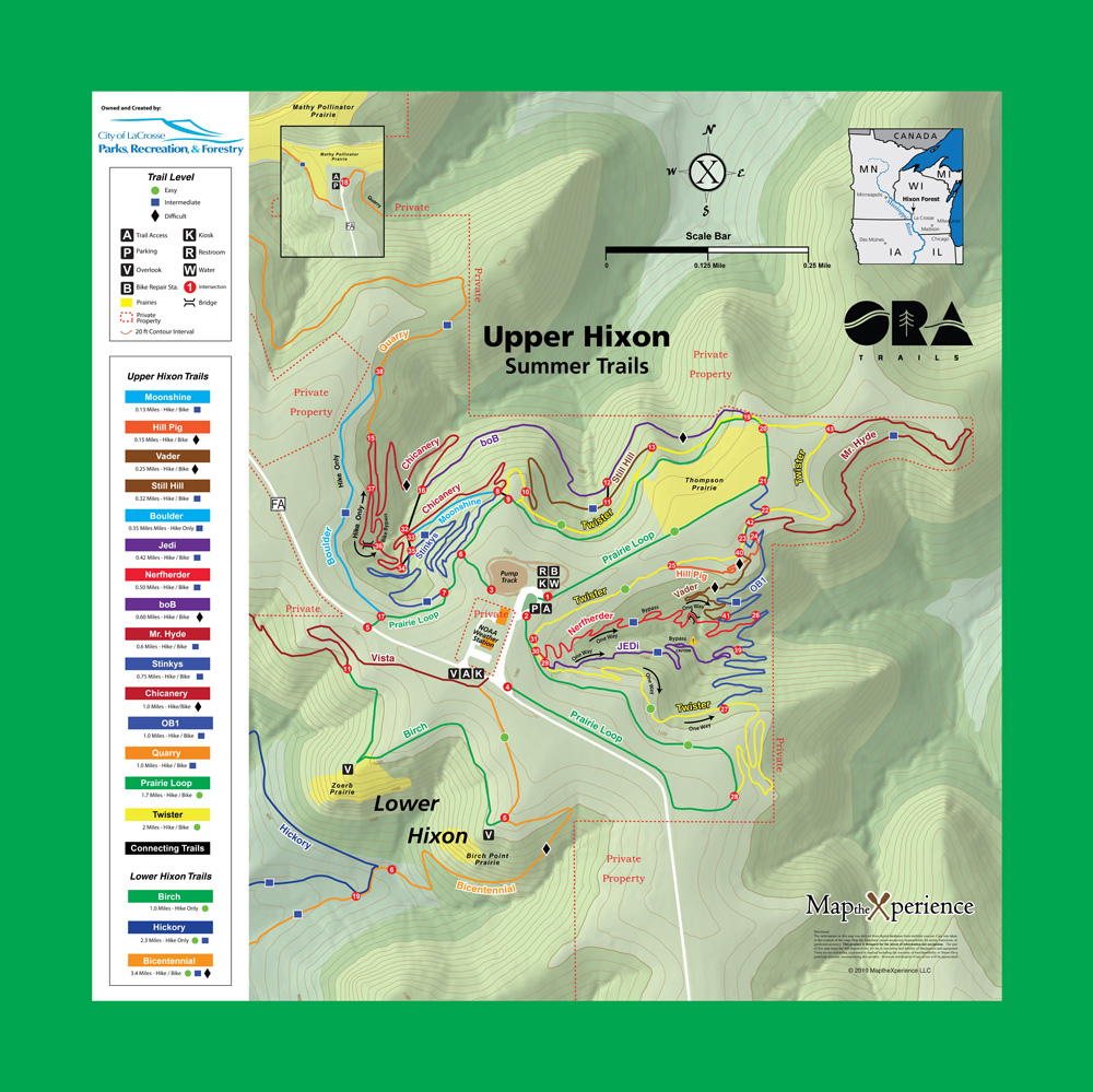
Upper Hixon Trails

Upper Hixon Trails are shared use trails for hiking, trail running, and biking. It is also home to the Star Wars Galaxy, a system of downhill gravity trails. During the winter, trails are groomed for fatbiking. Snowshoeing is allowed also allowed, but please note that access to a small portion of Twister and all of Mr. Hyde is limited from Nov 1 to Jan 1 (signs are posted).

Trail Descriptions

Upper Hixon

Distance: 12 miles
Difficulty: Beginner to Expert

Upper Hixon Trailhead

This trailhead is at the top of the bluff, as the name implies. The trailhead is central to the Upper Hixon trails and is home to a dirt pumptrack, fun for all ages.

Get Directions

Quarry Trailhead

This trailhead starts you on Quarry Trail, a great old school singletrack path that connects to the rest of the trails at Upper Hixon.

Get Directions

Vista Trail

This trail can be accessed from the Lower Hixon Trailhead in La Crosse.  It is 2 miles long with 700ft of elevation change.  A great trail riding up or descending, watch for hikers, running and bikers as this trail is often busy.  There are some steep sections, but overall the trail mixes in some downhill segments nicely as you climb for a break. It is mostly hard packed with a few rocky sections and one sandy corner. You’ll see a sign at the first crest of the trail, continue onward.  Once you reach end of the trail you can continue right onto Trail of Champions (Vista 2) which will take you to Upper Hixon Trailhead OR you can turn left and ride the remaining bit of trail onto the blacktop road called “Rim of the City’ Rd.  Turn right onto Rim of the City Rd, ride to stop sign, turn left onto County Hwy FA and ride to the end of the road where you’ll see Quarry Trailhead.

Trail of Champions Trail (Vista 2)

This trail connects Vista to Upper Hixon Trailhead or in reverse order gets you from Upper Hixon Trails to Vista Trail as a descent. The trail has a fair bit of punchy climbs in either direction, ride with caution.

Quarry Trail

This trail is old school hand cut singletrack fun, a little under a mile in length, and can be ridden in either direction but flows best when starting from the Quarry Trailhead.

Chicanery Trail

Old School hand Cut Single Track. This is a directional DH trail, with a spur connection to the quarry trail, or take it to the bottom and climb out of the Abyss Trail to Bob Trail.

Stinky’s Trail

Old School hand cut tight single track. This is a directional trail that starts at the Abyss intersection and ends at Prairie Loop.

boB Trail

boB is a throwback to old school hand cut single track trail with some new reroutes in 2018. It rides like a downhill trail when starting from Prairie Loop and vice versa when starting from Abyss.

Twister Trail

One of the original trails at Upper Hixon Park, this trail serves as a great introduction to riding hand cut single track. There are some log and skinny options that can be found on this trail.

Prairie Loop Trail

A trail used to connect other trails that is primarily grass and field.

OB1 Trail

Rebuilt in 2018, with more flow, berms and rollers. There are also optional rock face jumps. This trail is part of the climbing return system from the bottom of the downhill gravity trails.

JEDi Downhill Trail (Gravity Trail)

JEDi is a new Downhill Trail Built By Rock Solid Trail Contractors in June of 2019. It features large berms, large jumps and a 5-6 ft drop (with optional ride around).

Vader Downhill Trail (Gravity Trail)

Vader was created by Rock Solid Trail Contractors, completed in July 2019. This trail is raw and chunky with a filter feature rock drop at the start to set the tone for the trail. This is a double black diamond DH Only trail that features rock drops, rock berms, rock gardens, rock gaps, and rock steps.  High air pressure (30 psi) is recommended to avoid rim strikes and pinch flats.

Nerfherder Downhill Trail (Gravity Trail)

Downhill Trail Build by Rock Solid Trail Contractors in 2018. Designed as a intermediate Level DH with Jumps, Berms & Rollers. Best resembles a linear pumptrack.

Lower Hixon

Distance: 8 miles
Difficulty: Beginner to Intermediate

Lower Hixon Trailhead

Home to a lot of running and hiking trails (no biking) as well as shared-use access (hiking/running/biking) to trails that connect to the Upper Hixon and Gateway trail systems. Park here in the winter to access groomed skate and classic ski tracks.

Get Directions

Forest Hills Golf Course

Park in the lot and hop on the Forest Hill Connector trail to Wood Duck (also known as Caddyshack) and you’ll pop out at Lower Hixon. This lot is much larger than Lower Hixon and very easy to get to.

Get Directions

Hickory Trail | Hickory Connector

This is a relatively flat, hike-only trail that runs from the Lower Hixon parking lot to Bicentennial. Savanna trail branches off 1/2 a mile in, which will take you up the bluff towards Upper Hixon. In 2022, several meditation platforms were added after the branch to Savanna.

Bicentennial 2 Trail

Bicentennial (2) was rebuilt in fall of 2015 as a singular use double track trail. In spring of 2018, it was opened to bikes. Please be cautious of other users, as the DH portion of this trail is steep and fast.

Oak TrailOak Connector

Get to this hilly, hike-only trail from Log Loop Trail or by hopping onto Oak Connector on Bliss road (across from 29th St). Incorporate Oak Trail into a nice hiking loop by taking starting at Oak Connector to Oak Trail, a a right onto Log Loop, then to Aspen, which will pop you out past the Alpine Inn. Connect back down to 29th St by taking Compass Loop Connector (to the right of the Alpine Inn), Compass Loop North or South,  Wilder Way, and then Tramway.

Savanna

This steep, hike-only trail connects Hickory and Vista. Once you get to Vista, if you turn left you can take in the view at Lookout Prairie (worth the climb!), and turning right will take you towards Upper Hixon and the weather station.

Aspen Trail

Newly Rebuilt in Fall of 2018, and now open to Multi Use (Hiking, Trail Running, and Mountain Biking). This trail entrance is sneaky and easy to miss, located across the road from the overflow parking of Alpine Inn Bar.  Please respect other trail users.

Log Loop Trail

Log Loop is part of the Lower Hixon Trail System. This is a shared-use that was opened to bike use in the summer of 2019. If descending Aspen Trail you may use this trail to connect yourself back to the Lower Hixon Parking lot and vice versa for ascending Aspen.

Birch Trail (Educational Loop)

Birch is a relatively flat, hike-only connector between Vista and Bicentennial. It goes by Zoerb prairie which offers great views and is being actively managed to protect rare plants and animals.

Miller Bluff Trail

The Miller Bluff trail is a bi-directional hike-only trail that is both sustainable and enjoyable for a broad spectrum of trail users. The trail was built in the fall of 2021 and offers users breathtaking vista overlooks.

Forest Hill Connector/Wood Duck (Caddyshack)

This is a shared-use connector that allows safe access from the Forest Hills parking lot and under the railroad tracks. A gravel path running next to the golf course driving range then connects to the Lower Hixon parking lot. Another spur connects from the Myrick marsh parking lot, passing under Highway 16.

Skemp Ski Trail

Enjoy this 5.7km mostly bi-directional trail that is groomed on the Forest Hills Golf Course. Because this season is so short we ask that non-skiing traffic (hikers, runners, and snowshoers) avoid this area. Fatbikes are not permitted on the golf course. (This ski trail is not on trailforks, so please see the Lower Hixon Winter Trail Map for reference.)

Bicentennial Ski Trail

This bi-directional 1.8km ski trail follows the summer Bicentennial trail. Hikers, runners, snowshoers, and fatbikers may traverse this trail on the designated side opposite the groomed classic tracks, but we ask non-skiers avoid it if at all possible (hikers, runners, and snowshoers may use Hickory Trail). (This ski trail is not on trailforks, so please see the Lower Hixon Winter Trail Map for reference.)

Hickory Ski Trail

This short, bi-directional connector trail (293m) connects two points of the Bicentennial Ski Trail. Non-skiing traffic must stay on the designated side opposite of the groomed classic tracks. (This connector ski trail is not on trailforks, so please see the Lower Hixon Winter Trail Map for reference.)

Log Loop Ski Trail

This intermediate-expert one-way 850m loop provides skiers with a challenging climb. It is a connector to Oak Trail (hike-only) and Aspen Trail (shared-use) so non-ski traffic may be present but should use the designated side opposite the groomed classic tracks.

Fern Hill Connector

This bi-direction, expert-level trail connects Bicentennial and the golf course. It contains several steep climbs and tight turns. (This ski trail is new so it is not on trailforks or the Lower Hixon Winter Trail Map yet.)

The Gateway Trails

The Gateway Trail System on Grandad Bluff offers six miles of shared-use trails with neighborhood access points on 29th Street and Ebner Coulee Road. The project was initiated as a way to safely get hikers and bikers to the top of the bluff from La Crosse. By developing 160 acres of underutilized parkland into world class shared-use trails, the project connects multiple neighborhoods to natural spaces and to each other. The top of the bluff offers a variety of outdoor amenities with family-friendly limestone trails, rock climbing, and access to endless adventure on neighboring public land.

Distance: 6 miles
Difficulty: Beginner to Expert
History of the Gateway Trails

Goerge’s Point Trailhead

Situated at the top of the trail system on Grandad’s Bluff. You’ll have immediate access to a hiker and bicycle playground of family-friendly limestone trails, rock climbing, and good ol’ fashioned exploring.

Get Directions

Neighborhood Access Points

Access the Gateway Trails by foot or bike at these neighborhood access points. Parking by these points is highly discouraged. Please respect the neighbors around these access points and park at George’s Point or Forest Hills Golf Course.

Tramway